Nations of Canada
Champlain Gives It Another Go
In the twelfth instalment of an ongoing Quillette series on the history of Canada, Greg Koabel describes France’s halting efforts to create a permanent Canadian settlement in the early 1600s.
What follows is the twelfth instalment of The Nations of Canada, a serialized Quillette project adapted from Greg Koabel’s ongoing podcast of the same name.
In 1603, after several false starts, the French finally conducted a successful exploration mission on the St. Lawrence River. In part, the success of that voyage, which was the subject of our last instalment, emerged from its limited goals: For now, the French were merely explorers, not colonizers, and had no intention of spending the winter in Canada. Their objectives had been to learn more about the region (in order to select a suitable place for a settlement), and to strike up friendly relations with potential Indigenous allies.
 Greg Koabel
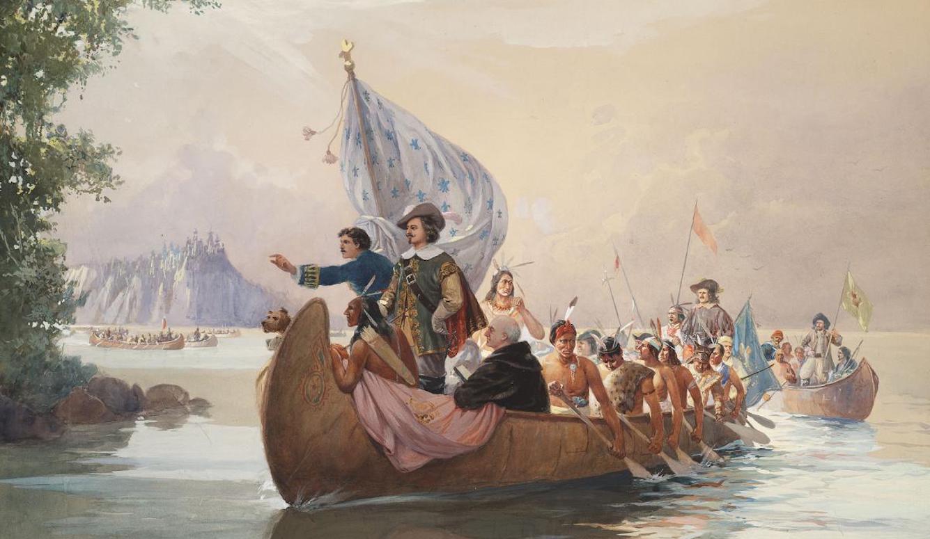
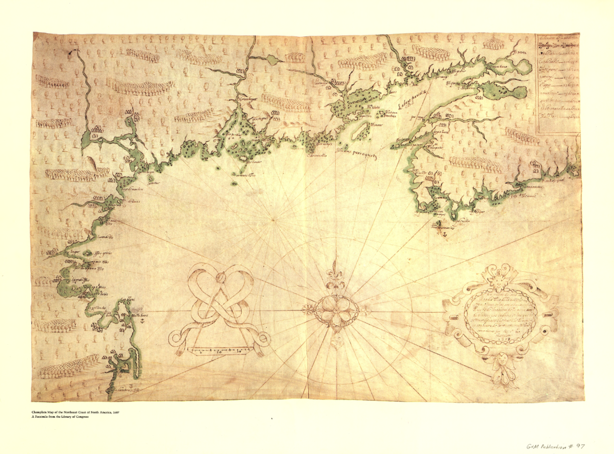
The royal cartographer attached to the voyage, Samuel de Champlain, delivered results on both fronts. He created detailed maps of the St. Lawrence, and gathered useful intelligence on what lay upriver, where no European had yet ventured. Perhaps more importantly, Champlain had the good fortune to come across a great assembly of Indigenous leaders at Tadoussac. As discussed previously, this was a broad collection of peoples from all across the region, celebrating their collective victory against the Iroquois to the south. Champlain was able to present the French as a potential ally in future battles with the Iroquois.
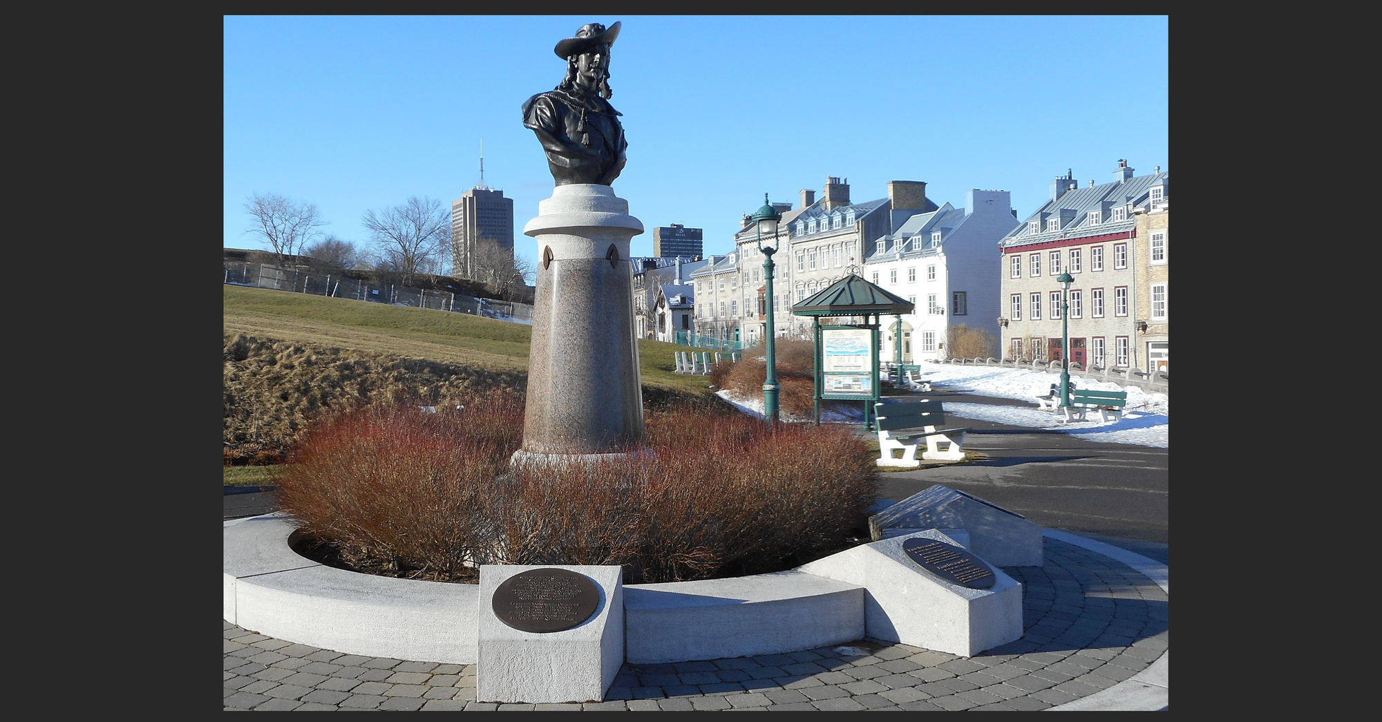
Greg KoabelBut back in France, changes at the top complicated things for Champlain and his colleagues. Aymar de Chaste, the aristocrat acting as the viceroy for France’s Canadian enterprise, had died. His replacement, the man who would decide the location of France’s new colony, was Pierre Dugua de Mons.
In many ways, de Mons was ideally suited to lead the Canadian colonial effort. Despite having been born into France’s aristocratic class, he had a head for commerce. Like Champlain and many of the merchants backing the Company that King IV had directed to monopolize the fur trade in the new world, de Mons was from the west coast of France, near the important port of La Rochelle. He had longstanding relationships with merchants, and had invested in various trans-Atlantic commercial schemes. In 1600, in fact, he’d personally joined Pierre de Chauvin on his expedition to Tadoussac, and thereby witnessed how difficult Canadian winters could be for French visitors.
Despite that sobering experience, de Mons remained convinced that there were huge profits to be made in the fur game. In modern terms, he was a bit of a venture capitalist.
De Mons was also a connected man at court. He descended from one of the leading Huguenot (i.e., Protestant) families in the kingdom, and had won the personal friendship of King Henri IV through military service in the Wars of Religion. With de Mons serving as vice-admiral and lieutenant-general of France’s possessions in the Americas, the Company could expect a fair hearing in the corridors of power.
But de Mons also brought with him two bits of baggage that would complicate France’s colonial project.
The first was his status as a Protestant in a largely Catholic country. For now, his friendship with the King (who himself had once been a Protestant) shielded him to some extent. But no king reigns forever. So there was always the possibility that de Mons’ Huguenot background would compromise the project he led.
The second problem—as some saw it—was that de Mons, having been traumatized by his experience with winter at Tadoussac, wasn’t inclined to return to the St. Lawrence, no matter how glowing Champlain’s reviews.
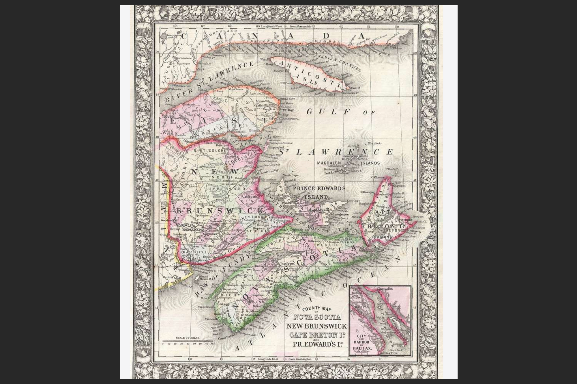
Instead, de Mons favoured a settlement in Acadia—a poorly mapped coastal region that lay about 600 kilometres southeast of Tadoussac. Back in the 1520s, Florentine explorer Giovanni da Verrazzano had become the first European known to have come across the region. But no European had really done a thorough survey since then.
Roughly speaking, this was modern-day Nova Scotia, combined with bits of New Brunswick and Maine. French fishermen had been visiting the waters in this area for almost a century by this point. More recently, fur traders had been stopping by in order to conduct business with the Mi’kmaq who lived there.
De Mons aimed to scout out an advantageous Acadian location for a winter settlement. Further explorations, to be conducted the following spring, would then hopefully uncover an ideal spot for a permanent base, from which the Company could enforce its fur monopoly.
The Frenchman wasn’t just scared of winter weather at Tadoussac. He also had security concerns about the St. Lawrence more generally. While Acadia sat on the open Atlantic, the approaches to the Gulf were guarded by Newfoundland, where large numbers of English ships assembled each fishing season. For now, France and England were at peace, but de Mons worried about the long term.
And even where the short term was concerned, many of the Englishmen who prowled the Grand Banks were no better than pirates. Few would think twice about sparking a diplomatic incident if it won them some easy booty.
Yes, the St. Lawrence basin drew in a fur market of continental proportions. But the Mi’kmaq of Acadia had been avid fur salesmen for decades, no less than the Algonquins and Innu who lived north of the river. Moreover, who knew what links might be developed through the unexplored waterways that moved inland from the coast? The 1603 voyage had uncovered rumours of mines in Acadia, and hints at rich mineral deposits. Jacques Cartier’s old dream of finding gold or some other precious resource in this new land still lingered.
Finally, de Mons may have been spurred on by European geopolitical developments. Just before the French 1603 voyage had set out, Queen Elizabeth of England died. She was succeeded by James VI of Scotland—now James I of England. One of the new King’s first priorities was to end England’s long war with Spain. (The Spanish were happy to agree, over-stretched as their Empire was.)
As de Mons and Champlain debated the destination of their 1604 voyage, Spanish diplomats were gathering in London to hammer out a peace deal. And an Anglo-Spanish peace had the potential to make Acadia and the whole northeastern seaboard less hospitable to French interests. Now at peace, England would be able to turn its attention to commercial ventures, and there were already rumours that the English had set their sights on America.
One group of merchants (based in London) were eyeing the Chesapeake, a large bay off the coast of modern Maryland and Virginia. A previous English attempt at colonization in this area had failed in the 1580s, but investors were ready to take another stab at it. More troubling for de Mons, another group, this one from England’s West Country, was considering a settlement further north. (Indeed, it would eventually decide on the Kennebec River in modern day Maine—an area within the rough boundary of what the French called Acadie.)
In other words, de Mons knew that if France failed to establish a permanent presence in the region, it risked surrendering the whole of it to the English. He also knew that, according to a seventeenth-century European understanding of international law, fishermen and seasonal traders counted for nothing as compared to settlers who occupied the land year-round. If de Mons wanted his fur monopoly to carry any weight in Acadia in the future, he needed to plant some Frenchmen there as soon as possible.
While Champlain had been eager to return to the St. Lawrence, losing this argument with de Mons did not affect his relationship with the new head of the Company. The two men may not have agreed on the details, but Champlain and de Mons shared a passion for the colonial project in Canada and a mutual respect for one another.
Moreover, while Champlain still harboured a desire to return to the St. Lawrence, he also had a motive to set his sights on a fresh destination: As a cartographer, he relished the opportunity to put his stamp on the first professional maps of the northeastern Atlantic coast.
He also hoped Acadia might provide the key to finding a way past the most frustrating part of his 1603 St. Lawrence adventure—the rapids at modern-day Montreal, which blocked any further French naval progress upriver. Champlain hoped that he was on the cusp of finding the legendary Middle Passage, which could turn any French fur-trading colony into a commercial hub of global significance.
Champlain had planned to search for a way around the rapids when he returned to the St. Lawrence. But Acadia offered an intriguing alternative. The Innu who’d escorted Champlain up the Saguenay River in 1603 had told him that (after a few portages) the waterway eventually led to a great salt sea in the north (a reference to what we now call Hudson Bay). Champlain suspected (wrongly, as it turns out) that yet another large river might directly link that sea with the St. Lawrence at a point above (i.e., to the west of) the impassable Lachine rapids.
As Champlain’s old friend Martin Frobisher had found, accessing that great northern sea from the Arctic was no easy task. But the largely uncharted coastline that lay south of the Gulf of St. Lawrence might provide an easier route. Between Acadia and the Chesapeake, there was more than 1,500 kilometers of poorly mapped coastline. It wasn’t unreasonable to hope that there was another entry point into the continent somewhere along that stretch.
In October 1603, just weeks after Champlain’s return from his first voyage, the Acadia plan received formal approval from the Crown. This was important because, while any permanent colony would be financed by private investors, their investment could be recouped only if the operation was covered by a royally granted fur monopoly.
However, following the usual pattern that I’ve discussed in previous instalments, this angered merchants who weren’t part of the official Company and its cozy monopoly arrangement. Almost immediately, resistance formed in Rouen, Saint Malo, and La Rochelle—which is to say, every one of the main ports involved in the fur trade. These were players who had real political influence in their communities. And over the winter of 1603-04, regional political institutions in Normandy and Brittany threw up roadblocks against the would-be colonists.
Here, the personal influence that de Mons enjoyed at court proved crucial. Following on a few sternly worded letters, written on the royal stationary, the dissident merchants relented. It would not be the last time that tensions between monopoly-holders and independent traders complicated France’s colonial project. But for now, the problem had been resolved.
De Mons himself led the three-ship 1604 expedition, which was staffed by about 130 men. Champlain came along, too, needless to say. His skills as a cartographer were essential to the work of selecting a location for a new French settlement. Moreover, events at Tadoussac the previous year had also demonstrated Champlain’s skills as a diplomat.
François Gravé (often referred to in historical texts as Pont-Gravé), the old sailor who’d been the monopoly’s enforcer in 1603, also returned for this second voyage. So did Jean de Biencourt de Poutrincourt et de Saint-Just—a 47-year-old aristocrat with a long string of honourary titles but little in the way of cash. Poutrincourt had more or less bankrupted himself during France’s civil wars, but was happy to do so in exchange for the honours the King bestowed upon him, and a bit of adventure. He had never really expressed much interest in Canada. But when his friend de Mons suggested colonizing a new world as an opportunity for the kind of excitement that peace-time France no longer offered, Poutrincourt took him up on it.
The expedition included a handful of other highborn aristocrats and gentlemen, as well as three clerics. Of these, two were Catholic and one was Huguenot—a reflection of the religious diversity of France’s colonial adventurers (or at least what passed for diversity in a society where almost everyone was Christian).
The rest of the contingent was comprised of soldiers, skilled artisans, and somewhat less skilled labourers (probably scoured from the kingdom’s prisons). Some had experience as hunters, as it was hoped that the colonists would be able to live off the land over the winter. Also on board were two master minters from the Balkans, who were charged with assessing the value of the minerals that Acadia was rumoured to hold.
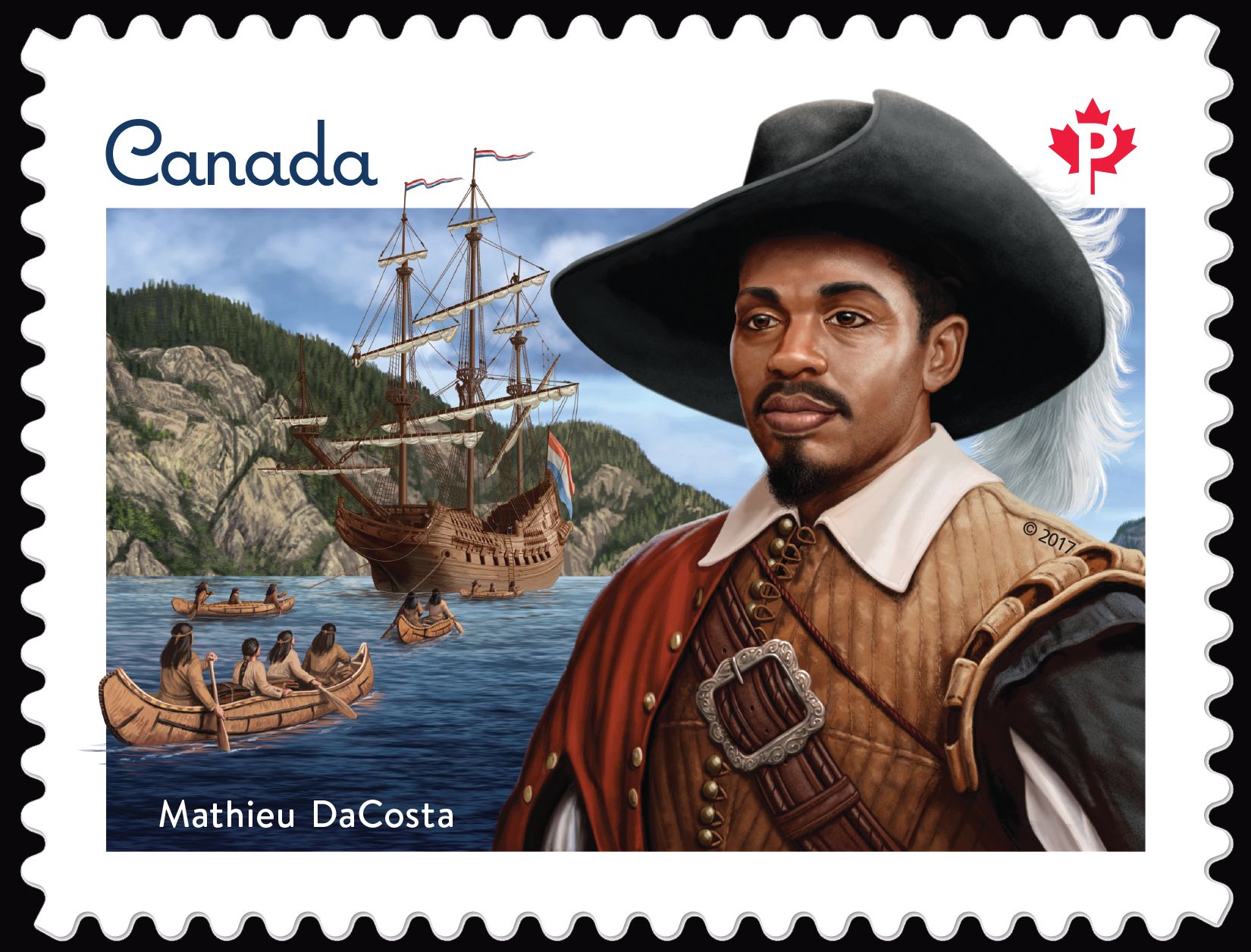
Another member was Mathieu da Costa, an African translator originally employed by the Portuguese. He is now remembered as the first free black person known to have arrived on the territory of what is now Canada.
After working with the Portuguese, da Costa had found his way into Dutch and English service before joining de Mons’ expedition as a translator. His linguistic skills were impressive, as he could work in English, French, Dutch, Portuguese, and (most importantly) the language of the Mi’kmaq, as well as the mish-mash of Basque and Algonquin tongues that served as the trade language for the region.
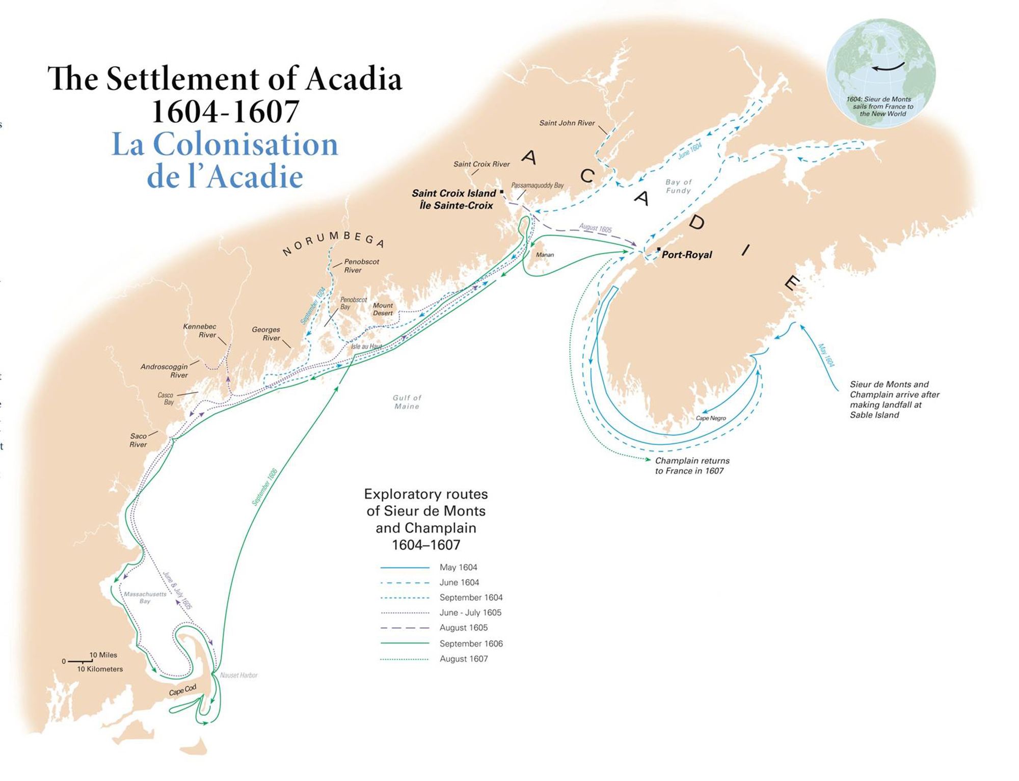
On May 1, 1604, the small fleet arrived at Sable Island, the site of Troilus de Mesqouez’s ill-fated French colonizing effort a few years earlier. They did not waste much time here, however. Indeed, the sight of it likely reminded de Mons and his colleagues of the difficult task ahead of them.
Soon after, the ships reached the mainland—specifically, the peninsula that is today part of Nova Scotia. Almost immediately, groups of Mi’kmaq came out in canoes to greet the new arrivals. This was the summer season, when the itinerant Mi’kmaq traditionally moved to their coastal settlements to ply the sea for fish. But the European fur trade was already starting to change local economic patterns. These new canoes, it was noted, were primarily designed for trade, not fishing. It was a good sign that de Mons could expect a brisk and profitable commerce in the area.
Very quickly, however, the expedition encountered a major obstacle: It turned out that they were not the only Europeans in the area. On May 12, the fleet encountered a ship out of the French port of Le Havre, commanded by one Jean de Rossignol.
Rossignol explained that he was trading in fur, under a license issued by none other than the French crown. De Mons replied that this was impossible, as he had a monopoly on all fur trade in the region. Upon inspection of Rossignol’s license, de Mons saw that it applied to the coast of Florida—a term that then described territory stretching from the modern state of Florida up to a vaguely defined border area near the St. Lawrence.
Notwithstanding the geographical vagaries at play, De Mons decided that this Rossignol character had overstepped. The trader was arrested, and his ship and cargo were seized.
On the one hand, this encounter marked the first successful execution of the fur monopoly. But the incident also served to highlight how difficult enforcement would be. Ambiguities over territorial rights might allow men such as Rossignol to dispute seizures of this type in the courts back home. And since lines of communication between France and the New World were slow and unreliable, it was impossible to receive timely instructions from France as to who was legally entitled to do what.
Moreover, Atlantic Canada was a vast territory, and it had really only been happenstance that allowed de Mons to come across Rossignol. How many other traders were out there, doing business under the table? Had Rossignol submitted to de Mons’ authority because of the monopoly? Or because his lone ship was outnumbered by de Mons’ trio? It was unclear whether de Mons would have the muscle required to enforce his monopoly in the face of real resistance.
It was the first sign that de Mons may have made a mistake in selecting Acadia for his colonial base. The volume of trade was far higher in the St. Lawrence—especially at Tadoussac, which was far, far away. Physical geography posed a challenge for any enforcement effort based in Acadia.
With Rossignol’s ship added to de Mons’ fleet, the expedition moved on to its primary mission—exploration. Here, Champlain took the lead, methodically charting the coast of modern-day Nova Scotia. Although the ships started on the east coast of the peninsula, on the open ocean, the real area of interest was the more protected coastline offered by the Bay of Fundy, which separates Nova Scotia from what is now New Brunswick.
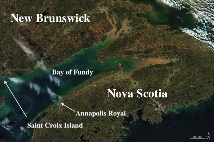
In the early summer, Champlain discovered a promising location on the bay’s coastline—a well-protected natural harbour that cut deep into the land. This was the site of modern-day Annapolis Royal. It looked easily defensible, and was surrounded by fertile meadows.
It was still early in the season though, and de Mons hoped for a base that would help the French extend their reach into the interior of the continent—and its unlimited supply of fur—rather than one located on a relatively small peninsula sticking out into the sea. Also, if Champlain was going to find a waterway that led to the St. Lawrence, it would be on the other side of the Bay Fundy. So Champlain marked the spot on the map as a potentially useful location, and the expedition continued its way around the bay.
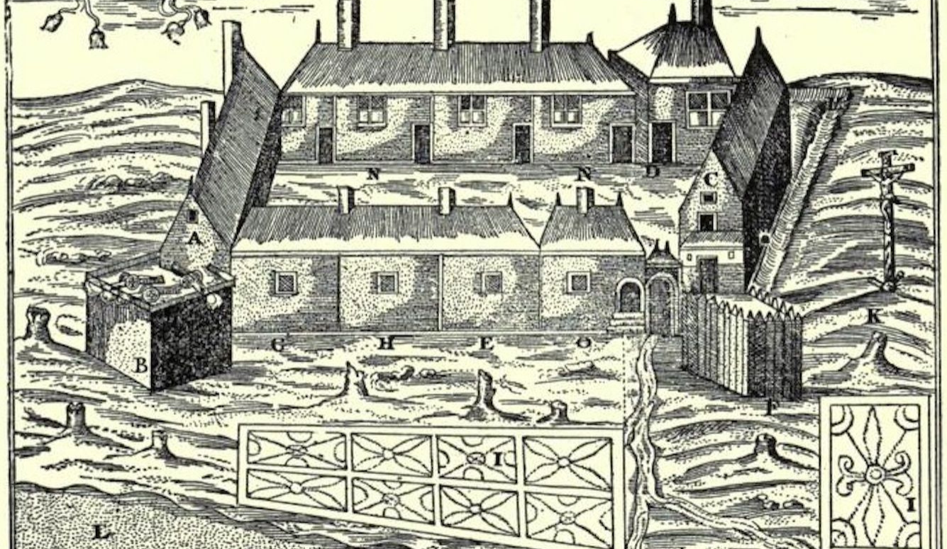
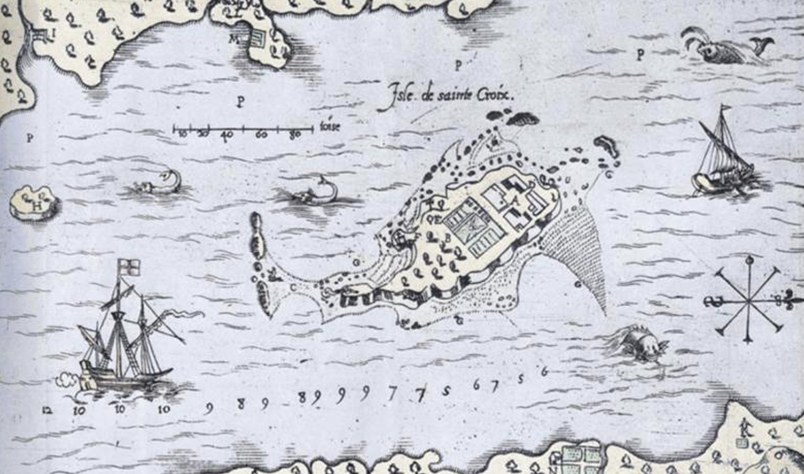
By August, the explorers had found what would become their winter base—Saint Croix Island (French: Île Sainte-Croix), in what is now known as the Saint Croix River. (Today, the river forms part of the border between Canada and the United States, with the island sitting in U.S. territory, just several hundred meters west of the international line.)
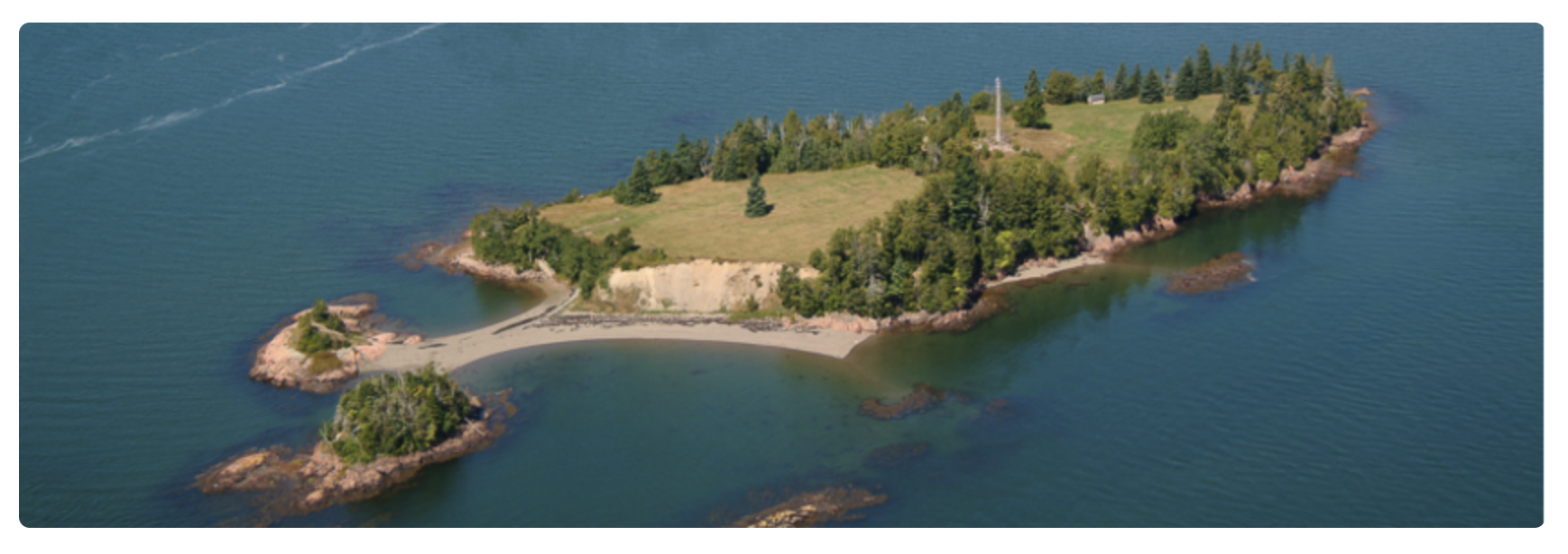
The tiny island appeared to offer security against potential raids (either by the Etchemin—the Algonquin-speaking tribe whose members resided on the west side of the bay—or European rivals). Cliffs covered three sides of the island, leaving only one avenue of approach. Saint Croix also lay at the southern end of the Bay Fundy, making it a good staging ground for further explorations down the coast (either in what remained of the summer, or the following spring).
The climate appeared inviting, too. The river provided all the fresh water the settlers would need. And the forests on either side of the river offered plenty of game, as well as a seemingly limitless supply of firewood. By latitude, Saint Croix was roughly in line with La Rochelle on the Atlantic coast of France. Both de Mons and Champlain had grown up in that area, and they were confident that a comparable winter would not pose a problem. (As noted in previous instalments, Europeans were then unfamiliar with the Gulf Stream, and its warming effect on western Europe.)
While the bulk of the expedition started work on winter quarters, Champlain took a small crew on a trip further south. He spent all of September scouting as far as the mouth of the Penobscot River, 150 kilometers down the coast. From there, he moved about 40 kilometers upriver, to roughly where the city of Bangor, Maine now sits.
Possibly with the help of da Costa, Champlain made friendly contact with the local Indigenous population and learned that, through a series of portages, the Penobscot linked up with the St. Lawrence to the north. He was also told of an even greater waterway, about 150 kilometers further southwest along the coast, now known as the Kennebec River.
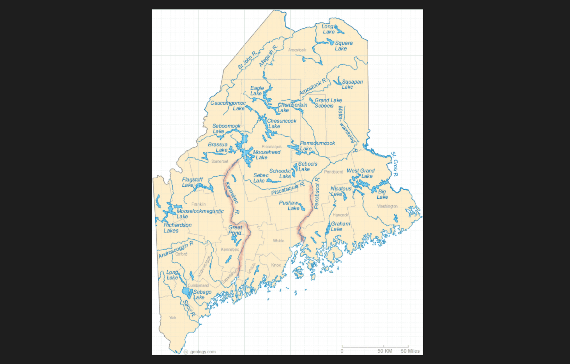
By this time, it was early October, and Champlain’s little exploratory team had to get home before winter set in. But the cartographer had whetted his appetite for future explorations in the spring. The coast was full of potential laneways that could lead the French to the great highway of the St. Lawrence—hopefully at a point to the west of the rapids.
Champlain returned to Saint Croix, where he saw that the construction of winter quarters was nearly complete. The project’s leader, de Mons, would stay the winter, as he had at Tadoussac a few years earlier. So, too, would Champlain, in order that he might resume his explorations as soon as spring came. Almost 80 other Frenchmen would remain as well, making this the largest winter colony since Jean-François Roberval’s disastrous stay outside Stadacona in the winter of 1542-1543 (whose fate was described in the sixth instalment).
Poutrincourt and Pont-Gravé took the rest of the men home, to report the mission’s success; sell the furs they had accumulated; and assemble a return fleet for the following summer. Saint Croix would doubtlessly require re-supply.
Soon after the ships disappeared over the horizon in October, the first snows fell. It was an ominous sign that the French had once again underestimated the severity of the North American winter.
It turned out that by prioritizing security, the colonists had put themselves in a bad position. Being trapped on an island, a lack of mobility was perhaps their greatest problem. Another problem was the Bay of Fundy itself, which is home to the highest tides in the world. This is partly because the back-and-forth flow of water sloshing around the bay (a naturally occurring motion known as a seiche) operates in tandem with the tides, thus creating resonant waveforms. The shape of the bay also plays a role: It is wide and unusually deep at its open end, but gradually becomes narrower and shallower at the shore end, where the tide can rise and fall by over 50 feet during the course of a day.
Saint Croix was located near the open end of the bay, so the French colonists avoided the tidal extremes. Even so, the movement of water wreaked havoc on the settlement. Over and over, the river froze, only for the ice to be shattered by another wave of incoming water. The result was a jagged, nearly impassable terrain of ice.
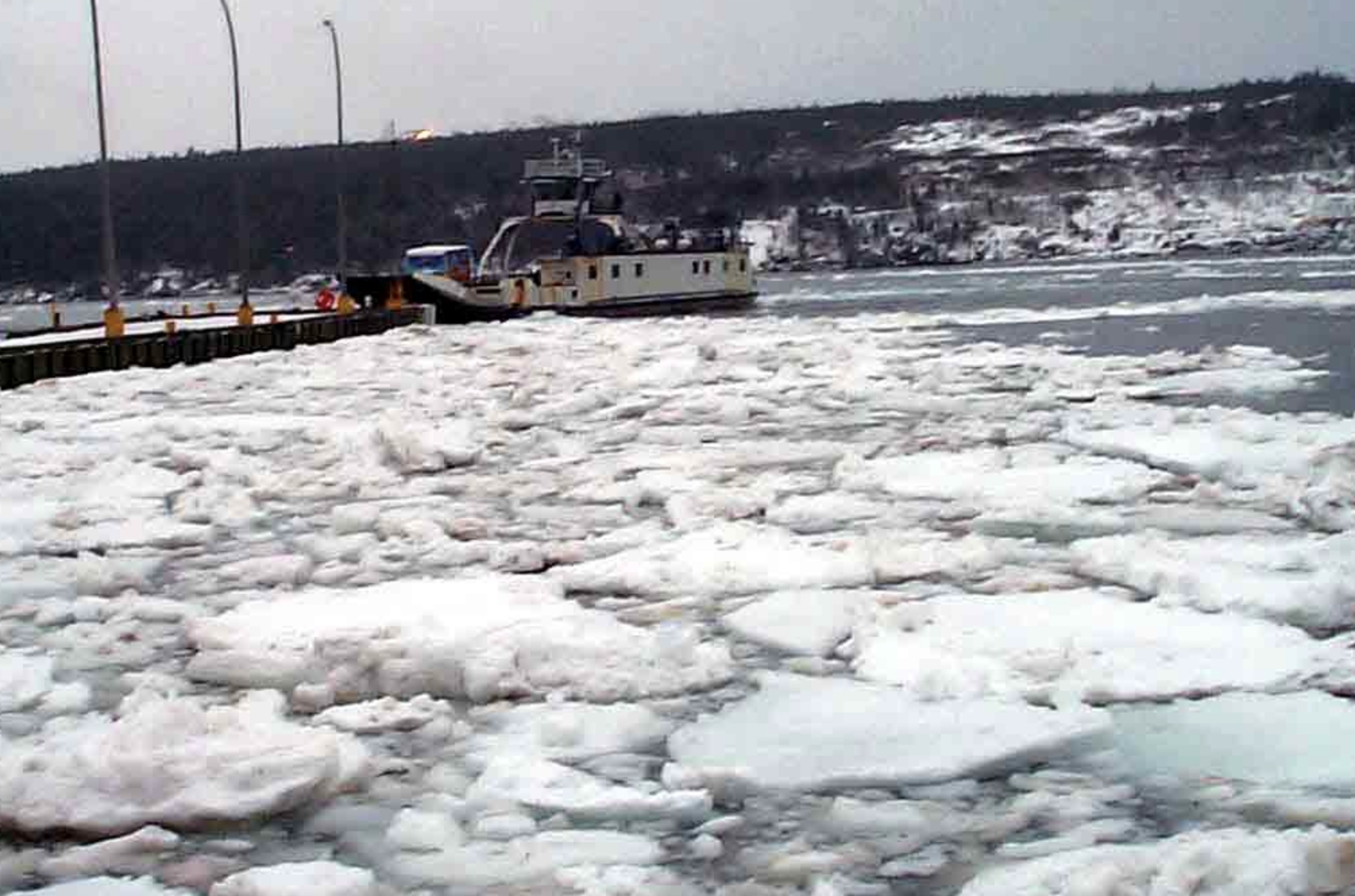
Small parties of men could go out in search of game or wood, but they had great difficulty bringing anything back through the frozen obstacle course. Those who survived the winter learned the hard way that firewood had to be stockpiled before the winter, when moving supplies was more feasible.
The colonists also found that European construction techniques were not suited to this climate. The simple wooden cabins they built could not keep out the cold, or even the snow. Even the most carefully built structure had gaps where logs joined together, through which freezing winds could enter. In the late summer, insulating every nook and cranny had seemed like a waste of time, especially for what was planned as a single-use winter habitation. But when winter came, the men found that the inside was scarcely warmer than the outside.
The cold affected the settlement’s provisions. Casks of wine and cider froze, despite being stored inside. It was yet another harsh lesson for French engineers. Only cellars, dug deep into the ground, could provide the protection necessary for supplies and men.
It was one of the worst winters the French had yet suffered on this side of the Atlantic, which was a high bar to clear (or rather a low one to get under). A lack of food and firewood left the men starving and cold. Champlain had hoped to apply Spanish methods of avoiding scurvy by relying on fresh meat from local game, but the hunters who’d gained their experience in the forests of France had difficulty working in this entirely alien environment.
Of the 79 men who stayed behind at Saint Croix in October, only 44 survived to the spring. Scurvy was responsible for most of the deaths. And nearly everyone was sickened to some degree. By late March, when the river began to thaw, only 11 men were healthy enough for regular work.
When Pont-Gravé returned with his supply ships a few weeks later, de Mons, Champlain, and the other survivors were happy to abandon the scene of their months-long torture. Unlike Rocheval in 1543, or Chauvin in 1601, however, de Mons wasn’t going to throw in the towel after just one disastrous winter.
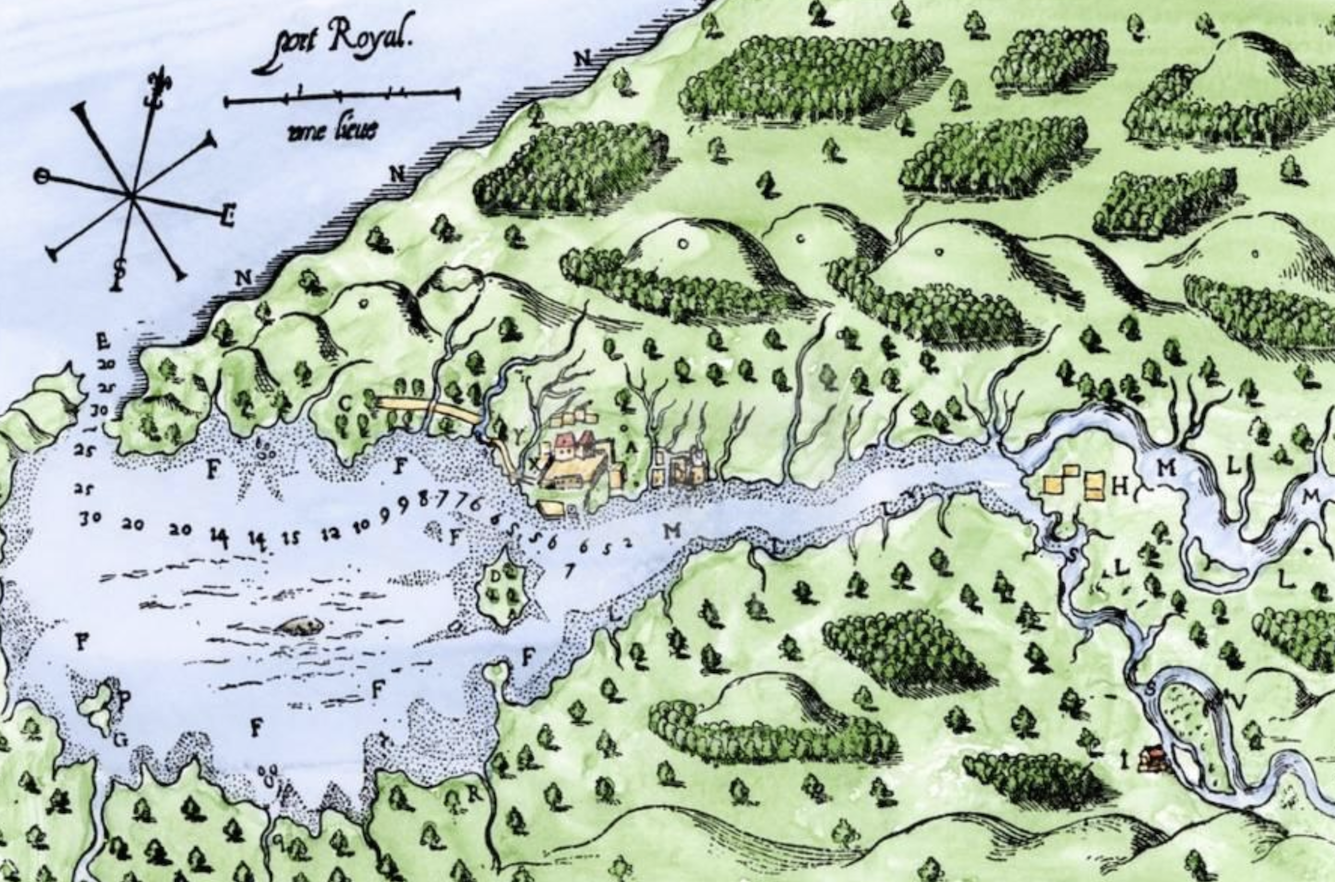
His first order of business was to relocate the base camp to that promising site they’d found, and left, on the eastern side of the Bay of Fundy in 1604. It was hoped that the protected harbour would shield the settlement from the worst of the elements. And by building on the mainland this time around, they could avoid the mistake of separating themselves from resources. Greater care would be taken in constructing their cabins. This was colonization by trial and error.
The new settlement, which they named Port Royal, also benefited from friendly relations with the local Mi’kmaq population. On the western side of the bay, the French hadn’t encountered any hostility from the neighbouring Etchemin. But neither was there any co-operation. This time, the French had reason to believe that they’d find aid if they needed it. (Plot spoiler: They would.)
For generations, various Mi’kmaq communities had co-operated with European visitors, from Norman fishermen, to Basque whalers, to fur traders out of La Rochelle. But the community that neighboured Port Royal was unusually friendly, even by those standards. They were led by an enigmatic chieftain named Membertou, who not only claimed to be over 100 years old, but also to have personally met Jacques Cartier seven decades earlier.
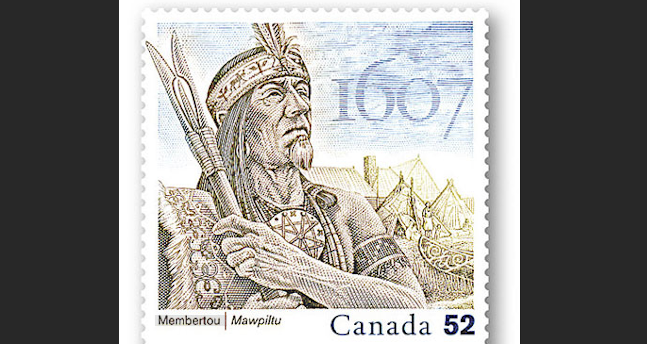
Membertou saw the French as powerful allies, and welcomed the regular trade that would come with a permanent settlement at Port Royal. This would give his people an advantage, not just against the rival Etchemin on the other side of the Bay of Fundy, but also against other Mi’kmaq groups.
It helped that the economic needs of the two peoples complemented each other well. The French saw the tideland landscape that surrounded Port Royal as ideal for agriculture, while the Mi’kmaq didn’t consider this land well-suited to the trapping that fuelled their economy. It really was a win-win scenario.
However, the division of land use and property rights that this arrangement implied was exactly that—implied. Technically, the French Crown was claiming ownership of all lands in Acadia. But de Mons saw no advantage in explaining that to Membertou. For now, he had no way of making good on those claims anyway, and it wasn’t clear whether such legal assertions would even translate serviceably between the two cultures (much less that the Mi’kmaq would agree to them). Better to cultivate local alliances, de Mons concluded, even if it was at the expense of French imperial pretensions.
Once construction of Port Royal was underway, de Mons headed down the coast with Champlain, to follow up on the initial explorations the cartographer had made in 1604. This time, the expedition pushed on much further.
The results, however, were disappointing. Part of the problem was the approach de Mons took to Indigenous contact. Champlain’s diplomatic successes at the Great Assembly at Tadoussac in 1603, and his effective intelligence gathering the previous autumn, had been in large part the result of his willingness to accept native hospitality. Unlike most European explorers we’ve studied, Champlain met with Indigenous leaders without armed entourages, and often alone. This open acceptance of hospitality was a crucial part of Indigenous diplomatic systems of trust and friendship.
De Mons, on the other hand, followed traditional European practices on this trip. He never left the safety of his ship, and limited his interactions with the populations they encountered to formal assemblies, at which both sides were equally represented. As a result, Champlain was much less successful in acquiring intelligence as he’d been in the past.
To be fair to de Mons, the disappointing results were not entirely his fault. Part of the problem was that the English had been through the area recently, and had abducted several Indigenous people near the banks of the Kennebec River. These were nations the French were hoping to establish relationships with, but they found them sullen and hostile. In the long term, there’d be an opportunity for the French to cast themselves as more benevolent than the barbarous English. But at the moment, the locals were understandably hesitant to trust any European.
Undeterred, de Mons and Champlain pressed on past the Kennebec, all the way to Cape Cod, where the coast cuts westward towards modern day New York and the mid-Atlantic coast beyond. Here, more than 200 kilometers from the Kennebec, relations had not (yet) been poisoned by English behaviour.
However, as Champlain led a party to shore, he encountered a different problem: His translator—probably Mathieu da Costa, though the records do not say so explicitly—failed him.
Da Costa could work with most Algonquin tongues. But these hosts spoke a language beyond even Da Costa’s expertise. Champlain had to resort to sign language and drawing charcoal symbols on rocks.
Frustration turned to violence a few days later, when a pair of Frenchman gathering fresh water had their copper kettle stolen. Metal vessels were greatly prized by Indigenous peoples, and had long been traded in exchange for furs. White visitors of the period often expressed irritation at the lack of respect paid by Indigenous people for rigid Western-style understandings of private property.
Whether this was a crime or a matter of cultural miscommunication, it quickly turned deadly. One of the Frenchman pursuing the kettle was knocked down by an arrow, then finished off by several assailants who fell on him with knives. In the ensuing scuffle, the French took a captive back to their ship. De Mons was able to defuse the situation by releasing the hostage and negotiating a tense truce. But Champlain’s hopes of gathering information about the local geography were dashed. Within a few days, the explorers were back in Port Royal, licking their wounds.
Once back in France, De Mons’ task was to relay the news of the disastrous winter at Saint Croix without scaring off investors or discouraging the Crown from continuing its support. To help make his case, he brought with him a baby moose, a hummingbird, and a 30-foot-long canoe—just a few examples of the wondrous riches of Acadia.
Meanwhile, 45 men stayed behind at Port Royal for the winter of 1605-06, led by the grizzled captain, Pont-Gravé. Luckily, this winter was much milder than the one that came before, with the first snows not coming until December 20. Membertou and his hunters also provided a steady supply of game. Scurvy was still a problem, however, with twelve men succumbing to the disease. It was an improvement on the year before, but a death rate above 25% didn’t portend a sustainable colony.
The spring of 1606 did little to lift the spirits of the men at Port Royal. Pont-Gravé led yet another exploratory expedition down the coast, but their ship was badly damaged on some rocks, and Pont-Gravé suffered a heart attack. He would eventually recover, but the party was forced to return to Port Royal, having achieved nothing.
By the beginning of July, things were getting desperate. The supply fleet on which the colony depended (due in May, or possibly early June) had still not arrived. Without it, the men would starve. Days turned to weeks, and the men became restless. Their leader, Pont-Gravé, remained incapacitated, and every day that went by, the suspicion that they’d been abandoned by the powers that be back home grew. What if de Mons had not been able to convince the Crown or the private investors that the colony was worth supporting? Without their backing, who would organize the needed supply run?
Keep reading

The Rise and Fall of Graham Platner

Reshaping the Middle East

Strong Opinions